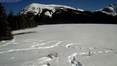
A stranded Edmonton hiker, west of Rocky Mountain House in Alberta, was discovered in the nick of time thanks to satellite camera technology developed by Delta based Nupoint Systems. The resourceful hiker stamped SOS into the snow to alert rescue teams. This Nupoint Systems’ Remote Viewer satellite camera technology captured a photograph of the SOS message and transmitted it to the RCMP via Alberta Agriculture and Forestry.
The hiker, accompanied by his dog, left the staging of Pinto Lake on Highway 11, near the Cline River, on Wednesday, March 13, on what he expected to be a four-day hike. When he realized he was in trouble, he was at Pinto Lake. He noticed the Nupoint Systems Remote Viewer satellite camera technology and hoped it would transmit a message to a rescue team.
Nupoint Systems, a BC based engineering company, has developed a unique satellite camera solution that monitors remote harsh environments 24/7—it takes regular photographs of remote areas and sends them back to headquarters via satellite networks. Hundreds of these systems are deployed across remote areas, where there is no cellular coverage, to monitor wildfires, snow and ice conditions, wildlife, natural resource infrastructures and more.
Wayne Carlson, President and CEO of Nupoint Systems, said, “We developed our Remote Viewer satellite camera systems just a few years ago, and we’re selling them across North America to environmentalists, government bodies, natural resource operators, law enforcement, and owners of remote buildings. We’re delighted that our technology was instrumental in saving the life of this Edmonton hiker and his dog.” The distress signal, a photograph of SOS stomped into the snow, was transmitted first to Alberta Agriculture and Forestry. As soon as it was recognized as a call for help on Monday, March 18, it was passed to the RCMP. Rocky Mountain House Search and Rescue and RCMP K Division air services personnel were deployed to Pinto Lake, where they found the man and his dog in good health. Both were airlifted back to the trailhead staging area.
About Nupoint Systems
Nupoint satellite communications solutions are designed by Nupoint Systems and enable environmentalists, governments, natural resource operators, and climate control specialists to transmit and access images from remote locations via satellite (Iridium and Globalstar) and cellular networks. When Nupoint monitoring systems are set up in remote locations, users can incorporate cameras, weather stations, and data sensors to work 24/7 to observe environmental conditions and manage its operations through a comprehensive system management client portal.


